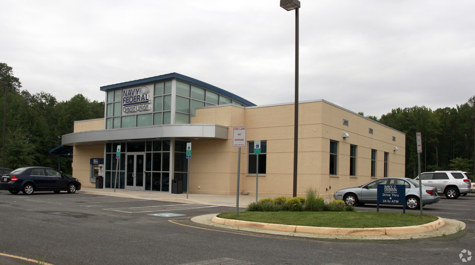
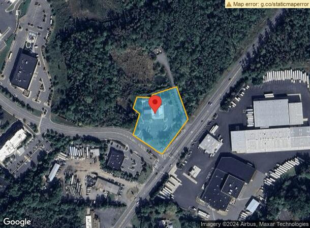
Property Record
100 Corporate Dr, Stafford, VA 22554

NEARBY LISTINGS FOR SALE OR LEASE
Property Detail
100 Corporate Dr
Washington-Arlington-Alexandria, DC-VA-MD-WV
Quantico Corporate Center
13C-C
PARCEL C 2.001 AC QUANTICO CORPORATE CENTER
Financialbuilding
Stafford
AE
Virginia
51179C0063G
c
2024
2 AC
2024
Stafford County
010201
Washington, DC
4,417 SF
DEMOGRAPHICS near 100 Corporate Dr
1 Mile
3 Mile
5 Mile
2024 Total Population
1,371
15,097
64,443
2029 Population
1,499
16,220
69,413
Pop Growth 2024-2029
+ 9.34%
+ 7.44%
+ 7.71%
Average Age
32
33
34
2024 Total Households
354
4,673
20,165
HH Growth 2024-2029
+ 11.30%
+ 7.77%
+ 7.95%
Median Household Inc
$110,381
$103,041
$98,381
Avg Household Size
2.90
3.10
3.00
2024 Avg HH Vehicles
2.00
2.00
2.00
Median Home Value
$335,256
$373,690
$368,002
Median Year Built
2001
2000
1994
Nearby Places
- Restaurants
- Banks
- Shops
- Fitness
- Groceries
PUBLIC TRANSPORTATION
COMMUTER RAIL
Quantico (Fredericksburg Line - Virginia Railway Express)
DRIVE
WALK
Distance
Quantico (Fredericksburg Line - Virginia Railway Express)
9 min
5.1 mi
AIRPORT
Ronald Reagan Washington Ntl
DRIVE
WALK
Distance
Ronald Reagan Washington Ntl
47 min
32.7 mi
Freight Ports
Port of Baltimore
DRIVE
WALK
Distance
Port of Baltimore
105 min
73.9 mi
Nearby Properties
Address
Land Use
TOTAL SIZE
Lot Size
Zoning
Address
Land Use
TOTAL SIZE
Lot Size
Zoning
470,850 SF
22,970.24 AC
A1
Address
Land Use
TOTAL SIZE
Lot Size
Zoning
122,323 SF
134.63 AC
A1
Address
Land Use
TOTAL SIZE
Lot Size
Zoning
140 SF
20.14 AC
R2
Address
Land Use
TOTAL SIZE
Lot Size
Zoning
142,920 SF
22.01 AC
R2
Address
Land Use
TOTAL SIZE
Lot Size
Zoning
143,136 SF
7.50 AC
M1
Address
Land Use
TOTAL SIZE
Lot Size
Zoning
142,128 SF
8.80 AC
M1
Address
Land Use
TOTAL SIZE
Lot Size
Zoning
140,976 SF
8.63 AC
M1
Address
Land Use
TOTAL SIZE
Lot Size
Zoning
17,551 SF
642.15 AC
A1
Address
Land Use
TOTAL SIZE
Lot Size
Zoning
48,996 SF
8.01 AC
R16
Address
Land Use
TOTAL SIZE
Lot Size
Zoning
54,000 SF
17.55 AC
R4
Address
Land Use
TOTAL SIZE
Lot Size
Zoning
270,475 SF
32.75 AC
M1
Address
Land Use
TOTAL SIZE
Lot Size
Zoning
90,000 SF
7.83 AC
M1
Address
Land Use
TOTAL SIZE
Lot Size
Zoning
81,000 SF
7.58 AC
M1
Address
Land Use
TOTAL SIZE
Lot Size
Zoning
33,099 SF
2.74 AC
M1
Address
Land Use
TOTAL SIZE
Lot Size
Zoning
57,128 SF
2.70 AC
B2
Address
Land Use
TOTAL SIZE
Lot Size
Zoning
26,599 SF
74.75 AC
A1
Address
Land Use
TOTAL SIZE
Lot Size
Zoning
35,276 SF
5.50 AC
R16
Address
Land Use
TOTAL SIZE
Lot Size
Zoning
152,563 SF
22.44 AC
A1
Address
Land Use
TOTAL SIZE
Lot Size
Zoning
47,520 SF
6.24 AC
R16
Address
Land Use
TOTAL SIZE
Lot Size
Zoning
39,498 SF
3.64 AC
B2
Address
Land Use
TOTAL SIZE
Lot Size
Zoning
48,668 SF
2.27 AC
M1
Address
Land Use
TOTAL SIZE
Lot Size
Zoning
29,510 SF
5.86 AC
R2
Address
Land Use
TOTAL SIZE
Lot Size
Zoning
29,872 SF
1.97 AC
M1
Address
Land Use
TOTAL SIZE
Lot Size
Zoning
46,934 SF
6.99 AC
M1
Address
Land Use
TOTAL SIZE
Lot Size
Zoning
44,986 SF
2.50 AC
B2
Address
Land Use
TOTAL SIZE
Lot Size
Zoning
34,030 SF
19.86 AC
R4
Address
Land Use
TOTAL SIZE
Lot Size
Zoning
29,904 SF
5.29 AC
R16
Address
Land Use
TOTAL SIZE
Lot Size
Zoning
8,000 SF
1.12 AC
B2
Address
Land Use
TOTAL SIZE
Lot Size
Zoning
140.62 AC
A1
The World's #1 Commercial Real Estate Marketplace
Connect with us
© 2025 CoStar Group
The information above has been obtained from sources believed reliable. While we do not doubt its accuracy we have not verified it and make no guarantee, warranty or representation about it. It is your responsibility to independently confirm its accuracy and completeness. Any projections, opinions, assumptions, or estimates used are for example only and do not represent the current or future performance of the property. The value of this transaction to you depends on tax and other factors which should be evaluated by your tax, financial, and legal advisors. You and your advisors should conduct a careful, independent investigation of the property to determine to your satisfaction the suitability of the property for your needs.